CED alum integral in launching COVID-19 information hub
Lawrie Jordan (BLA ’73) is an alumnus of the College of Environment and Design and current executive at Esri, one of the largest geographic information system companies in the world. Lawrie was integral to the launch of Esri’s free-to-use COVID-19 Geographic Information Systems (GIS) Hub, a website with a wealth of resources for anyone to use. We connected with Lawrie to ask him questions about the Hub, his role in developing it, and his time at UGA.
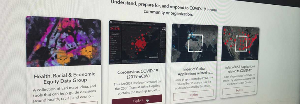
What tools can be found on Esri’s COVID-19 GIS Hub? Who are they for?
From the beginning of the COVID-19 pandemic, Esri surged its Disaster Response Team and worked closely with Johns Hopkins University (JHU) and the World Health Organization (WHO) to stand up a dynamic dashboard showing the global growth of the disease. This cloud-based tool leverages the power of geography and location analytics, with authoritative data from JHU and WHO being updated multiple times a day and successfully sustaining more than 1 billion hits per day worldwide. You can see the COVID-19 GIS Hub in action here.
Building on that foundation, the Hub provides an expansive set of online resources to lend support to communities, organizations, and individuals in need. These tools primarily consist of new maps, apps, informational dashboards, and supporting services that are focused on addressing specific needs associated with COVID-19, including:

Lawrie Jordan (BLA ’73)
- Vulnerable Populations
- Available Hospital Beds
- COVID-19 Testing Sites
- Travel Restrictions
- Contact Tracing (under development)
- Predictive Analytics
- Business Continuity
- Small Business Recovery
- Approaches to Safely Reopening
These are just a few of the tools available, and the full range can be seen at the Esri COVID-19 GIS Hub site.
What is your role in developing and launching the COVID-19 GIS Hub?
I’ve been fortunate to have worked with all forms of geospatial information for more than 40 years, with emphasis on imagery from satellites, aircraft, and drones. GIS technology provides us with an optimal environment to combine those sources of data with additional social, economic, statistical, health, and other natural resource layers. This enables us to see patterns, changes, and trends that affect us over time in totally new ways, including the multiple impacts of a crisis such as this pandemic.
At Esri we collaborate as a “team of teams,” and one of my roles is to provide thought leadership and industry outreach. I work with my colleagues and teammates to raise awareness across the world of new capabilities such as the COVID-19 GIS Hub, and to help inform and connect those in need. Tools such as this give us a new view of current conditions, as well as a new vision of what an improved future can look like.
What is a lesson you learned at UGA that you still carry with you while working at Esri?
One of the most valuable lessons that I learned as a UGA student (and frankly a recipe for overall success in your career and life) is the importance of “bringing your A-game” to everything that you do, and to “play all in, all the time.” CE+D’s Landscape Architecture course curriculum, the outstanding faculty, and the CED Design Studio environment naturally lends itself to this, and it sets the table for a high-energy pattern of productivity and innovation to thrive.
To follow this “all-in” recipe consistently, however, there’s a positive string attached. You have to stay healthy both physically and mentally, which adds two more important ingredients to the mix: regular exercise and a good diet.
And finally, the “secret ingredient” in this recipe is to put others first. Be of service to others and focus on helping them be successful first, rather than yourself. When you do this, you’ll find that you will succeed in numerous ways, far surpassing your own expectations. And then everything just gets better.
 Provided by the Georgia Museum of Art